Description: Der interoperable INSPIRE-Datensatz beinhaltet Daten vom LBGR über Reflexionssesimische Horizonte 2D BB, transformiert in das INSPIRE-Zielschema Geologie. Die Horizonte entsprechen einer Ableitung aus dem 3D-Untergrundmodell Brandenburgs (B3D) in Form eines 2D-Datensatzes. Das 3D-Modell B3D stellt den Untergrund Brandenburgs in Form ausgewählter reflexionsseismischer Horizonte bis in eine Tiefe von ca. 7000 m dar. Der Datensatz wird über interoperable Darstellungs- und Downloaddienste bereitgestellt. --- The compliant INSPIRE dataset contains data from the LBGR on sesimic reflection horizons 2D BB, transformed into the INSPIRE annex schema Geology. The horizons correspond to a derivation from the 3D subsurface model of Brandenburg (B3D) in the form of a 2D data set. The 3D model B3D represents the subsurface of Brandenburg in the form of selected seismic reflection horizons down to a depth of approx. 7000 m. The dataset is provided via compliant view and download services.
Global identifier:
Uuid(
    a15dafaa-5e47-40b8-b804-59cc87939f27,
)
Origins: /Land/Brandenburg/LGB /Bund/GovData
Tags: Brandenburg ? Geologie ? Untergrund ?
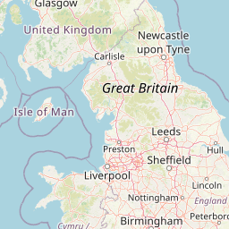
Bounding boxes: 11.2657° .. 14.7658° x 51.3591° .. 53.559°
License: dl-by-de/2.0
Language: Deutsch
Issued: 2025-05-08
Modified: 2025-05-26
Time ranges: 2025-05-08 - 2025-05-26
Accessed 1 times.