Description: Polygon of a special metadataset from the mapbender registry
Global identifier:
Url(
    "http://www.geoportal.rlp.de/registry/spatial/dataset/62946b60-61ab-480f-bf0c-6635b7ba54a8",
)
Types:
Origins:
/Land/Rheinland-Pfalz/GeoPortal.rlp
/Land/Rheinland-Pfalz/open.rlp
Tags:
Rheinland-Pfalz
?
Bebauungsplan
?
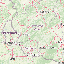
Bounding boxes:
6° .. 8.5° x 48° .. 51°
License: dl-by-de/2.0
Language: Deutsch
Organisations
-
GeoPortal.rlp (Bereitsteller*in)
-
Zentrale Stelle GDI-RP (Herausgeber*in)
Issued: 2023-12-06
Modified: 2023-12-06
Time ranges:
1960-07-01 - 2025-06-05
Resources
Status
Quality score
- Overall: 0.83
-
Findability: 0.65
- Title: 0.00
- Description: 0.41
- Identifier: true
- Keywords: 1.00
- Spatial: BoundingBox (0.50)
- Temporal: true
-
Accessibility: 1.00
- Landing page: Specific (1.00)
- Direct access: true
- Publicly accessible: true
-
Interoperability: 1.00
- Open file format: true
- Media type: true
- Machine-readable metadata: true
- Machine-readable data: true
-
Reusability: 0.67
- License: ClearlySpecifiedAndFree (1.00)
- Contact info: false
- Publisher info: true
Accessed 1 times.